Planning a Canadian road trip isn’t about creating a perfect route; it’s about mastering the art of the strategic trade-off.
- GPS time estimates are a starting point, not a rule. Factoring in a 25% “buffer” for spontaneous stops and unpredictable delays is essential for a realistic schedule.
- Fuel costs aren’t fixed. Strategic refueling based on provincial price differences can save significant money, turning a mundane task into a logistical advantage.
Recommendation: Treat your itinerary as a dynamic resource management plan, constantly balancing the triangle of time, fuel, and experience to make the most of your journey across Canada.
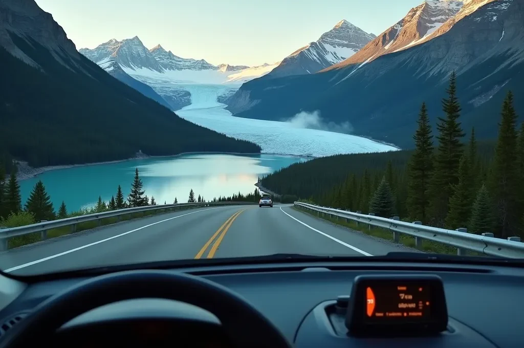
Every great Canadian road trip begins with a spark of excitement and, almost immediately, a navigation app. You map the distance from Vancouver to Banff or Halifax to the Cabot Trail, and a neat little ETA appears. This, you think, is your plan. But as any seasoned traveler of Canada’s vast landscapes knows, that initial plan is often the first casualty of the road. The journey is not a simple line on a digital map; it’s a complex logistical puzzle where scenery, time, and budget are in a constant state of negotiation.
The common advice is to “plan ahead” and “be flexible,” a frustrating contradiction. Traditional planning focuses on static checklists of sights and routes, while true flexibility often feels like chaotic wandering. This approach misses the fundamental reality of a Canadian road trip: it is an exercise in dynamic logistics. Success doesn’t come from a rigid itinerary but from understanding how to manage your resources—time, fuel, and energy—in a constantly changing environment. It’s about making smart trade-offs, not just following directions.
This guide will reframe your approach. Instead of just listing destinations, we will equip you with a logistician’s mindset. We will explore why standard tools fail in unique Canadian terrains, how to accurately calculate your travel time beyond the GPS estimate, and how to turn fuel stops into a strategic advantage. Forget the rigid plan; it’s time to learn the art of the strategic road trip, where every decision optimizes the balance between efficient travel and unforgettable discovery.
This article will guide you through the key logistical challenges and strategic solutions for planning your Canadian adventure. The following sections break down everything from navigation failures to fuel-saving tactics, providing a comprehensive framework for a successful journey.
Table of Contents: A Logistician’s Road Trip Blueprint
- Why Isn’t Google Maps Enough in the Rockies or the Maritimes?
- Average Speed vs. Photo Stops: Why You Should Add 25% to Your GPS Time
- How to Bypass Major Construction Sites That Paralyze Canadian Roads in Summer
- The Rigidity Trap: Why Leaving Room for the Unexpected Enhances the Experience
- Where to Stop for a Nap: Official Rest Stops vs. Mall Parking Lots?
- How to Cut Your Gas Bill on the Trans-Canada Highway Without Wasting Time
- The Mistake of Typing an Address at a Red Light: Why It’s Passible of a Fine
- Trans-Canada Highway Road Trip: Must-See Stops From Victoria to St. John’s
Why Isn’t Google Maps Enough in the Rockies or the Maritimes?
In the urban grid, Google Maps is an infallible guide. But in the vast, rugged expanses of the Canadian Rockies or the winding coastal roads of the Maritimes, relying solely on a single, data-dependent app is a critical logistical error. The primary failure point isn’t the software, but the infrastructure it depends on. Vast stretches of Canada’s iconic highways are cellular dead zones. According to the Canadian Radio-television and Telecommunications Commission, a staggering 13.4% of major roads have no mobile service. This means no real-time traffic updates, no ability to search for a new destination, and no way to call for help if needed. Your primary navigation tool simply vanishes when you might need it most.
This isn’t a problem that’s easily solved. The economic and geographical challenges of installing infrastructure in these areas are immense, leaving coverage gaps that are unlikely to be filled soon. Therefore, the core principle for a Canadian road trip planner must be navigational redundancy. You need a layered system where if one tool fails, another is ready. This means embracing offline solutions not as a “just in case” but as a fundamental part of your planning toolkit. Having multiple, independent map sources is the only way to guarantee you remain in control of your route, no matter how remote the landscape becomes.
Case Study: The British Columbia Highway Coverage Gap Crisis
A plan by Rogers Communications Inc. to install new cell towers along a 92-kilometre stretch of highway between Hope and Keremeos in British Columbia illustrates the challenge perfectly. The project’s estimated cost ballooned from an initial $9.7-million to over $70-million, leading the company to back out. This case highlights how the difficult mountainous terrain makes expanding cellular coverage economically unfeasible for carriers, cementing the reality of persistent dead zones for travelers in regions like the Rockies.
Your Action Plan: Essential Offline Navigation Redundancy
- Download Google Maps offline areas before departure, ensuring they cover your entire planned route and potential detours.
- Install a secondary app like MAPS.ME, which uses OpenStreetMap data and often has different details, as a backup.
- Save offline maps in multiple, separate apps for critical redundancy in the most remote areas.
- Always download map data while on a stable Wi-Fi connection to preserve your mobile data for when you have service.
- Remember to update your offline maps at least every 30 days to ensure they reflect the latest road changes and points of interest.
Average Speed vs. Photo Stops: Why You Should Add 25% to Your GPS Time
A GPS calculates your Estimated Time of Arrival (ETA) based on one primary factor: driving at the legal speed limit without stopping. This calculation is fundamentally flawed for a Canadian road trip, where the journey itself is the destination. The difference between the GPS ETA and your actual arrival time is what we can call the “experience buffer.” This buffer accounts for the unpredictable but inevitable stops that define a scenic drive: the sudden appearance of an elk herd, a breathtaking viewpoint that demands a photo, or a charming small-town bakery you can’t resist.
A good logistical rule of thumb is to add a minimum of 25% to your total GPS driving time. A 4-hour drive on paper should be budgeted as 5 hours. This isn’t a sign of inefficient travel; it’s a mark of realistic planning. Ignoring this buffer is the most common cause of rushed, stressful road trips, forcing you to skip spontaneous opportunities because you are “behind schedule.” The goal is to build flexibility directly into your timeline, transforming potential delays from frustrations into planned parts of the adventure. By quantifying this time, you give yourself the freedom to enjoy the journey without the pressure of a constantly ticking clock.
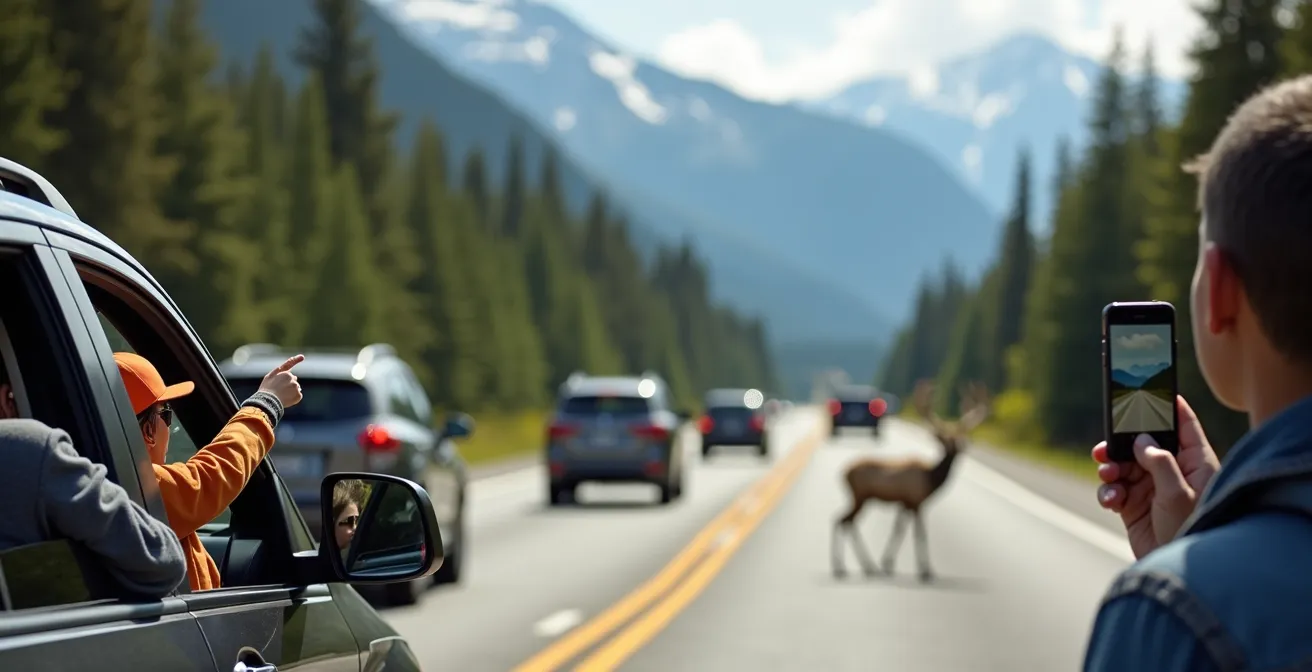
This buffer becomes even more critical when you analyze the types of stops. A quick photo at a roadside pullout might only take 15 minutes, but an unexpected “bear jam” in Jasper or a short hike to a waterfall can easily consume an hour or more. Structuring your day with this extra time allocated is the key to a relaxed and fulfilling experience.
The following table provides a framework for understanding how different types of common Canadian road trip stops can impact your schedule. Use it to build a more realistic time budget for your daily drives.
| Stop Type | Time Required | Frequency | Examples |
|---|---|---|---|
| Roadside Viewpoint | 15-20 minutes | Every 50-100km | Sea-to-Sky pullouts, Lake Louise viewpoint |
| Wildlife Viewing | 30-60 minutes | Unpredictable | Bear/elk jams in Jasper, whale watching Cabot Trail |
| Trail/Waterfall Hike | 90-120 minutes | 1-2 per day | Johnston Canyon, Takakkaw Falls trails |
| Small Town Lunch | 2-3 hours | Daily | Nelson BC, rural Quebec villages |
| Agricultural Delays (Prairies) | 15-45 minutes | Seasonal (harvest) | Combines on Highway 1 Saskatchewan |
How to Bypass Major Construction Sites That Paralyze Canadian Roads in Summer
The great irony of Canadian road trips is that the best time to travel is also the peak season for road construction. From May to October, Canada’s highways come alive with repair crews working to fix the damage from harsh winters. This inevitably leads to lane closures, major detours, and long, frustrating delays, especially on critical arteries like the Trans-Canada Highway. A single construction zone, like the multi-year Kicking Horse Canyon project in British Columbia, can add hours to your trip and completely derail a tightly planned schedule.
Thinking like a logistician means treating construction as a predictable variable, not an unfortunate surprise. Your strategy should be proactive, not reactive. The key is to leverage the official, real-time information provided by each province. Every province and territory maintains a “511” road information system, accessible via app or website. This is your most powerful tool for proactive rerouting. Checking these systems every morning before you depart is a non-negotiable part of your daily routine. It allows you to anticipate major blockages and plan alternative routes before you’re stuck in a 10-kilometre-long traffic jam.
Your Action Plan: Provincial 511 Systems for Construction Avoidance
- Alberta 511: Essential for checking road conditions and construction updates through critical mountain passes like Banff and Jasper.
- DriveBC: Your go-to resource for navigating the massive Highway 1 construction zones through Kicking Horse Canyon and other BC routes.
- Quebec 511 (Québec 511): Crucial for navigating the complex web of Montreal-area bridge repairs and extensive seasonal road work across the province.
- Ontario 511: Use this to track major Trans-Canada Highway improvements and detours, particularly in Northern Ontario.
- Morning Ritual: Check the 511 apps for all relevant provinces the morning of your travel for the most current, real-time updates.
- Offline Prep: Before entering a known construction zone, download offline maps of potential alternate routes identified through the 511 system.
The Rigidity Trap: Why Leaving Room for the Unexpected Enhances the Experience
One of the biggest mistakes a road trip planner can make is falling into the rigidity trap—creating an itinerary so detailed that it leaves no room for magic. The most cherished memories of a Canadian road trip are rarely the planned-out stops; they are the serendipitous discoveries. It might be a sign for a local butter tart festival in a small Ontario town, a detour that leads to a hidden waterfall, or an impromptu stop to watch a pod of whales from the Cabot Trail.
The logistician’s approach to this is not to abandon planning, but to embrace structured flexibility. This means intentionally building “unplanned” time into your day. Instead of scheduling every hour, you might block out an entire afternoon for “exploration” in a specific region. This gives you a framework—you know your end-point for the day—but allows for spontaneous decisions within that structure. This is the key to balancing progress with discovery. As many travelers find with famously hard-to-access spots like Lake O’Hara, sometimes the unplanned detours become the main event.
This mindset also encourages you to interact with your environment in a more meaningful way. A simple coffee break can become a source of valuable intelligence. This is the essence of a strategy that savvy travelers use across the country.
The ‘Tim Hortons Tip’ strategy: using coffee breaks in small towns as an opportunity to ask locals for recommendations on hidden gems
– Canadian Road Trip Community, Cross-Canada Travel Forums
This simple act of asking a local, “What’s one thing we shouldn’t miss around here?” can yield far better results than any travel guide. It turns a mundane stop into a strategic opportunity for discovery, perfectly embodying the spirit of structured flexibility.
Where to Stop for a Nap: Official Rest Stops vs. Mall Parking Lots?
Driver fatigue is a serious risk on long-haul Canadian drives. Planning where to take a break or a quick nap is a crucial safety consideration, but the options and rules are far from uniform across the country. The quality and availability of rest stops vary dramatically from one region to another, creating another logistical puzzle for the road tripper. What’s permissible in one province could get you a fine or a tow in another.
In the high-traffic Windsor-Quebec corridor, you’ll find modern, full-service plazas like Ontario’s ONroute centres, which offer restaurants, clean washrooms, Wi-Fi, and fuel. These are generally safe and permit limited-hour parking. However, once you venture into the Prairie provinces or Northern Ontario, facilities become much more basic. You’re more likely to find simple picnic areas with outhouses, if anything. While overnight parking is often informally tolerated out of necessity in these remote areas, it’s not always officially sanctioned. The common fallback of using a Walmart or mall parking lot is also a gamble, as many municipalities have enacted bylaws prohibiting overnight stays in commercial lots.
The key is to do your research and use tools designed for this purpose. Apps like iOverlander provide crowd-sourced information on legal and informal overnight parking spots, but it’s always wise to look for official signage or check local municipal websites when in doubt. Assuming the rules are the same everywhere is a recipe for a rude awakening.
The following table illustrates the significant regional differences in rest stop infrastructure, helping you manage expectations and plan your rest strategy accordingly.
| Region | Rest Stop Quality | Amenities | Overnight Parking |
|---|---|---|---|
| Windsor-Quebec Corridor | Full-service plazas | Restaurants, washrooms, WiFi, fuel | Limited hours allowed |
| Prairie Provinces | Basic pull-offs | Picnic tables, outhouses | Generally permitted |
| Northern Ontario | Minimal facilities | Unserviced pull-offs | Informal tolerance |
| Yukon/NWT | Wilderness stops | Often no facilities | Necessity-based acceptance |
How to Cut Your Gas Bill on the Trans-Canada Highway Without Wasting Time
Fuel is one of the biggest expenses on a Canadian road trip, but most travelers treat it as an uncontrollable cost. A logistician, however, sees it as an opportunity for strategic arbitrage. Gas prices are not uniform across Canada; they vary significantly due to provincial taxes. For example, according to government data, average gas prices per litre can vary from $1.366 in Manitoba to $1.938 in British Columbia. This price difference is not random; it’s a predictable pattern you can exploit.
The strategy is simple: plan your refueling stops to maximize purchases in lower-cost provinces and minimize them in higher-cost ones. Filling up a 60-litre tank completely in Alberta before crossing into British Columbia can save you over $30 in a single stop. This requires planning ahead using an app like GasBuddy to see real-time prices along your route. You can then calculate the “detour value.” Is driving 10 minutes off the highway to save 8 cents per litre worth it? On a 60-litre fill, that’s a saving of $4.80 for 10 minutes of your time—often a worthwhile trade-off.
Beyond strategic timing, simple driving habits can yield significant savings. Maintaining a steady highway speed between 90-100 km/h is the sweet spot for fuel efficiency in most vehicles. Using cruise control on flat stretches helps maintain this constant speed and saves fuel. Furthermore, reducing drag and weight by removing unnecessary roof racks can improve your vehicle’s fuel consumption by a surprising 10-20%. These small, consistent actions add up to hundreds of dollars in savings over a cross-country trip.
Your Action Plan: Strategic Fuel Planning for a Cross-Canada Trip
- Use an app like GasBuddy to track real-time fuel prices along your planned route and identify low-price zones.
- Plan to fill your tank completely in provinces with lower gas taxes, like Alberta, before entering more expensive ones like British Columbia.
- Calculate the “detour value”: a 10-minute detour off the highway that saves 8 cents/litre on a 60L tank translates to a $4.80 saving.
- Maintain steady highway speeds (90-100 km/h) and use cruise control on flat terrain for optimal fuel efficiency.
- Remove empty roof racks and other sources of drag, and reduce excess weight in the vehicle to improve consumption by up to 20%.
The Mistake of Typing an Address at a Red Light: Why It’s Passible of a Fine
In the flow of a road trip, it’s tempting to use a red light or a traffic jam to quickly type a new address into your phone or check your route. This seemingly harmless act is a major and costly mistake in Canada. Distracted driving laws are incredibly strict and, crucially, they apply even when your vehicle is temporarily stopped. From a legal standpoint, if you are in the driver’s seat and the car is on a public road, you are in control of the vehicle. Touching your phone for any reason is illegal.
The penalties are not trivial. They are designed to be a powerful deterrent and vary by province, but they are consistently severe. In provinces like Ontario and British Columbia, being caught touching your phone at a red light can result in a fine of over $1,000, along with major demerit points that can significantly impact your insurance rates. This isn’t a minor traffic ticket; it’s a serious infraction with hefty financial consequences.
The only legal way to use your phone for navigation while driving is through 100% hands-free operation. This means the phone must be securely mounted in a cradle, and all commands must be given by voice. Any physical interaction—tapping, swiping, or holding the device—is prohibited. The safest and most logical strategy is to have your passenger act as the navigator or to program your entire day’s route before you even start the car. A momentary convenience is not worth the risk of a massive fine and a serious mark on your driving record.
Key Takeaways
- Effective planning is about dynamic logistics, not a fixed itinerary. Success lies in balancing time, fuel costs, and scenic opportunities.
- Always add a 25% time buffer to GPS estimates to account for inevitable and enjoyable stops like wildlife viewing, photo opportunities, and small-town exploration.
- Leverage provincial 511 systems to proactively check for summer construction and plan detours, and use fuel-price apps to strategically refuel in lower-cost provinces.
Trans-Canada Highway Road Trip: Must-See Stops From Victoria to St. John’s
A successful road trip across Canada, a journey spanning over 7,821 kilometres along the Trans-Canada Highway, is the ultimate logistical achievement. Applying the principles of dynamic planning allows you to move beyond a simple list of “must-see” locations and start making strategic choices. Instead of asking “What should I see?”, the better question is “What is the best stop for my current balance of time, budget, and interest?”
For example, if you have a full day and are looking for a high-value scenic detour, venturing into Alberta’s Dinosaur Provincial Park is an excellent trade-off, despite the 60km detour. In contrast, if you’re on a tight schedule through Northern Ontario, the Terry Fox Memorial near Thunder Bay is a perfect “efficient cultural stop”—it’s powerful, moving, and located directly on the highway, requiring minimal time investment. The logistician’s mindset even applies to route selection. When crossing the Rockies, choosing the Yellowhead Highway (Route 16) over the Crowsnest Highway (Route 3) offers similar travel time but with gentler grades, resulting in better fuel economy for larger vehicles or RVs.
This final table isn’t just a list of places; it’s a strategic framework. It categorizes potential stops based on their logistical impact, allowing you to build an itinerary that is not only memorable but also smart, efficient, and perfectly tailored to your resources.
| Category | Stop | Province | Time Investment | Fuel Impact |
|---|---|---|---|---|
| High-Value Scenic Detour | Dinosaur Provincial Park | Alberta | 3-4 hours | 60km detour |
| Efficient Cultural Stop | Terry Fox Memorial | Ontario | 30 minutes | Right on highway |
| Fuel-Saving Swap | Yellowhead Route vs Crow’s Nest | AB/BC | Similar time | Less elevation gain |
| Indigenous Heritage | Agawa Rock Pictographs | Ontario | 2 hours | Short detour |
| RV-Friendly Overnight | Provincial parks | All | Overnight | Off-highway camping |
Now that you have the logistician’s framework, you’re ready to plan a Canadian road trip that is not only an adventure but a masterclass in strategic travel. Start mapping out your own balance of scenery and savings today.
Frequently Asked Questions About Driving in Canada
Is it legal to sleep in your car at rest stops in Canada?
The legal status varies significantly by province and municipality. Ontario’s ONroute plazas generally allow limited overnight parking for safety, but some provinces prohibit it entirely in their rest areas. It is crucial to always check local bylaws or look for posted signs, as rules can change.
Can I park overnight at Walmart in Canada?
While some Walmart locations in the US are famous for allowing RV parking, this is less common and more restricted in Canada. Many Canadian municipalities have bylaws that prohibit overnight parking in commercial lots. The risk of receiving a fine or being towed varies by city, so it’s best not to assume it’s allowed.
What apps help find legal overnight parking in Canada?
Apps like iOverlander are invaluable resources. They provide crowd-sourced data that helps distinguish between simple daytime picnic areas and confirmed legal or tolerated overnight spots. However, always verify the information with recent reviews or official sources, as policies can change frequently.
Can I touch my phone when stopped in traffic or at a red light?
No. The vast majority of Canadian provinces and territories prohibit any physical interaction with a hand-held phone while you are in control of a vehicle. This includes when you are stopped at a light or in a traffic jam. The law considers you to be operating the vehicle.
What’s the only legal way to use navigation while driving in Canada?
The only universally legal method is to use hands-free voice commands or to have a passenger manage the device. For a driver to use a phone for navigation, it must be securely mounted in a cradle and fully programmed before the vehicle is in motion. Any tapping or swiping while driving is illegal.
Do distracted driving laws differ between Canadian provinces?
Yes, the penalties differ significantly, which is why it’s so important to be cautious. While the principle of “no touching” is consistent, the fines and demerit points vary widely. Penalties can range from a few hundred dollars to over $1,000 with potential license suspension, making it critical to adhere to the strictest interpretation of the law in every province you drive through.